The Swedish initiative of Vision Zero is gaining momentum in the USA. Washington DC Mayor, Muriel Bowser, has taken a strong lead on Vision Zero as a direct response to the US Department of Transportation’s Mayors’ Challenge for Safer People and Safer Streets. The aim for Vision Zero is to ultimately improve pedestrian and bicycle transportation safely, whilst removing the chance of any road accidents.
The objective for Mayor Bowser and her team in Washington DC, is to reach zero fatalities and reduce serious injuries caused by traffic accidents by 2024. To help the Government achieve this goal, the District Department of Transportation recently launched an interactive Vision Zero Map, where residents can click a location and type in notes to describe any problems on the road network within Washington DC.
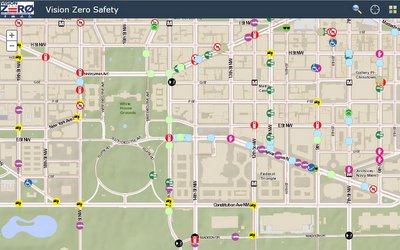
The map gives users an opportunity to highlight a wide variety of safety issues they observe or encounter. These are categorised on the map using icons to help identify the risk to drivers, pedestrians or cyclists.
The data collected from the map serves to inform the DOT about improvements that are needed in the road network. It’s all part of the Mayor’s “challenge activites”, one of which is to “identify and address barriers to make streets safe and convenient for all road users, including people of all ages and abilities and those using assistive mobility devices”.